


General information » Location
The location of the MNP
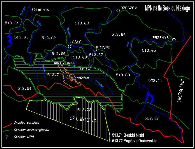
From the geographic point of view the Magura National Park covers the central and the most representative part of the Beskid Niski Mts. in the Polish Carpathians.
The Beskid Niski Mts. is a watershed, border range spreading over the length of about 100 km between the Kamienica valley and the Sadecka Basin in the west and the Oslawa and Oslawica valleys in the east. It forms a 30-40 km wide belt on the both sides of the Polish - Slovakian state frontier.
The Beskid Niski Mts. are a crosswise topographic law in the Carpathian curve, the lowest point is the Dukielska Col (502 m a. s. l.). The highest points are Lackowa Mt. (997 m a. s. l.) in the Polish side and Busov Mt. in Slovakia (1002 m a. s. l.).
The eastern border of the Beskid Niski Mts. is at the same time a fragment of the line dividing the Carpathians into the eastern and western parts.
In the area of the Beskid Niski Mts. a few smaller geomorphologic units can be distinguished in the landscape. The Magura National Park is situated within the area of the geomorphologic unit called Pasma Magurskie (Magura Ranges).
The Magura National Park lies within the area of seven districts:
Malopolskie Province:
· Lipinki,
· Sekowa,
Podkarpackie Province:
· Debowiec,
· Krempna,
· Nowy Zmigrod,
· Osiek Jasielski,
· Dukla.
The great majority of the Park’s area (90 %) is situated in the Podkarpackie Province, only the north-western fragment of the Park lies in the Malopolskie Province.