


Nature » Unanimated nature » Geology
Geology
The Magura National Park is situated in the area of the Flysch Carpathians, formed of the large tectonic units called nappes. Geologically these are quite young deposits – dating from the Late Cretaceous and the Tertiary. Their forming is connected with leaving in the inner-mountain water basins deposits of soil coming from the older mountains erosion. These deposits were transformed into the alternate layers of sandstones and shales during the process of sedimentation, during further orogenic processes they were uplifted, folded and moved towards the North-East, forming the system of overlapping nappes. The Park spreads mainly over the area of the Magura Nappe and, to a lesser degree, over the area of the Dukla Nappe, the Silesian Nappe and the Grybow Nappe.
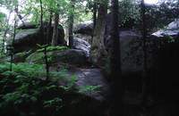
Diabli Kamien phot. Olimpiusz Wenhrynowicz
The lithostratigraphy of the units mentioned above is as follows (The Inanimate Nature and Soils Protection Impact Statement – A. Slaczka 1999):
1. The Magura Unit
In the area of the Park there is only the northern part of the Magura Unit represented by the Gorlice Subunit. Its profile starts from the Late Cretaceous-Palaeocene layers, locally turning into the Palaeocene layers from Swiatkowa. The Eocene is represented by the variegated shales in the northern part and the hieroglyph layers in the southern part. On the Eocene and Oligocene border starts the sediments of Magura sandstones, which locally are covered with younger elements – the Oligocene layers.
2. The Grybow Unit
This unit is shown in the tectonic window of Swiatkowa. It is built of deposits from Eocene to Oligocene (hieroglyph layers, Cergowa marls, Grybow shales, Cergowa layers). They are strongly tectonically disturbed what, in connection with a slight exposure degree in the outside stream beds areas, makes the carrying out of their borders very difficult.
3. The Dukla Unit
Within the MNP there are only small fragments of it near Myscowa represented by the Eocene – Oligocene sandstones of Mszanka, Oligocene Cergowa marls, Cergowa layers and Krosno layers.
4. The Silesian Unit
This tectonics system and small weathering resistance of the uplifted deposits are the base of the current main relief features. For these reasons the Beskid Niski Mts., being the largest crosswise topographic law in the Carpathians, are considered as low and medium-high mountains.
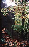
Diabli Kamien phot. Ewa Augustyniak
The effects of the weathering processes, especially within the most resistant to weathering Magura layers, are worthy noticing for tourists. The beauty and uniqueness of these forms were the reasons for protecting them before the Park was founded – the Kornuty reserve or the nature monument Diabli Kamien (Devil’s Stone). Quite interesting are also rock groups within Zamczysko Mt. in the Mrukowa region or within the waterfall on Folusz. Also the caves should be mentioned with one of the longest in the Flysch Carpathians – the Mroczna Cave, which is situated within the Kornuty reserve and its corridors measures in total 175 m.
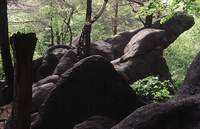
Diabli Kamien phot. Olimpiusz Wenhrynowicz